
Exactly four hundred years ago the name “Ukraine” first appeared on a geographical cartograph [map]. On the map of the Grand Duchy of Lithuania. Within the circles of historic cartographic professionals, the map upon which the name of a country was first conceived is called her passport. Thus, the 2013 Passport for Ukraine was created exactly four hundred years ago!
31.12.2013 17:40 Rostyslav Khotyn, UNIAN publications
original: http://www.unian.ua/news/615330-400-rokiv-evropeyskomu-pasportu-ukrajini.html
Ukraine’s “Passport” is a map from 1613 with the title “Magni Ducatus Lithuaniae Caeterarumque Regionum Illi Adjacentium Exacta Descriptio…” (Grand Duchy of Lithuania and the rest of the land adjacent to it, a description…) in the Lower Dnieper between Rzhyshchiv and Kanev – just below Kyiv – marked in Latin is: “Volynia Vlteririor quae tum Vkraina tum Nis ab altis vocitatur” (Eastern Volyn, whose name was also Ukraine and bottom) – this is how the “passport” is recorded for the first time, as Ukraine, on the European map.
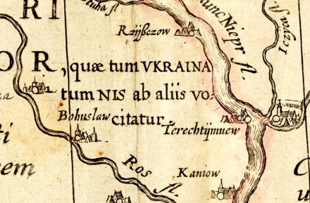
The name “Ukraine” appears for the first time on a map from 1613
“As regards the term ‘bottom’, it’s adequacy causes no doubts if we assess the whole of the territory covered by the map from the position of Vilna, now Vilnius, which was at that time the capital of the principality [Duchy]”, – states the specialized website Vkraina.com, explaining that on the map Ukraine is indeed at the bottom of the Principality of Lithuania.
The second version [of the map], not geographical, is that the map has marked the open territories as “below” – from the then capital, Vilnius, – it is a version in which the term “bottom” designates all of the lower flow of the river Dnieper, – actually, the current Ukrainian lands of Lower Dnieper [River].
Interestingly, the addition to the map of the Grand Duchy of Lithuania also has a map of the lower reaches of the Dnieper River – with reference material in Latin about Ukrainian Cossacks and Dnieper rapids, as well as the designation of the location of the Zaporizhian Sich – back then it was on Tomakivtsi.
The author of the Map of the Grand Duchy of Lithuania is Tomasz Makowski, with the participation of Maciej Strubicha, the map was created in 1603. And published – a decade later, by a very famous 17th century publisher of atlases, Dutchman Johannes Blau in Amsterdam, who was associated with the “golden age” of Dutch cartography of the Age of Discovery. The map was issued under the official pseudonym of Blau – Willem Jansson Blau. The map engraver is Gessel Herritts.
The map’s “sponsor” was the Lithuanian Prince Mikolaj Krzysztof Radziwill [Nicholas Christopher Radziwill] (1549-1616), who was called “the [little] Orphan”. He outfitted the geographical trip and collected the materials for Tomasz Makowski and Maciej Strubich’s map. The map was published separately starting in 1613, and first entered into atlases only in 1630. The last known copy of the cartograph was issued in 1647.
“In 1586, having just received the prince’s table, Radziwill sent an expedition led by Strubich to explore the lands of the principality, which at that time consisted of Poland and the biggest part of Right-Bank Ukraine. The work of the cartographer was so scrupulous, and the engraver’s images so refined, that Radziwill’s map of Lithuania is considered one of the most striking events in the development of 17th century European cartography and it remained the main source of geographical knowledge of the region for at least the next 150 years”- writes the historical site Volyn.
Radziwill’s map is considered one of the masterpieces of European cartography
“In general, Radziwill’s cartograph is a basic, well-planned source of the history of Ukrainian 17th century cartography. It is therefore obvious that [Guillaume Le Vasseur de] Beauplan, used it in his work “- adds the site, mentioning the author’s “Description of Ukraine” regarding Guillaume Le Vasseur de Beauplan, who also created beautiful cartographs of Ukraine, but later – in the middle of the 17th century.
A masterpiece of European cartography
“Radziwill’s map is one of the most important examples of European cartography of the late 16th – early 17th centuries and is one of the most significant contributions to the mapping of the entire continent,” – said Barry Lawrence Ruderman, an expert on ancient maps from California, USA.
The map covers the territories of the Baltic Sea in the north to Breslov in the Ukrainian Podillia in the south, from the origins of the Vistula River in the west to Chernihiv in the east. The map also shows the area between the cities of Kyiv, Krakow, Warsaw, Riga, Koninsberh, Gdansk, Lviv (Leopolis in Latin). Kyiv is pictured in great details of churches and city walls. Moscow is not on the map.
“The map holds a very prominent place in European cartography … and was also a big step forward in mapping the lands that were then part of Poland”- Karol Buczek wrote in his book, “History of Polish Cartography”.
The map of the Grand Duchy of Lithuania in 1020 marked the towns and villages – only the actual borders of the Principality of Lithuania were put on the map with 511 cities, 31 villages and one monastery.
The key battle of the first European summit
The stay of Ukrainian lands under the Grand Duchy of Lithuania influenced a general international, interfaith and linguistic tolerance, as well as two important events that have played a very important role in the history of Ukraine.
“We have been a state for more than a century – under the Grand Duchy of Lithuania. Let us recall the Battle of Blue Waters – it was a landmark battle! Then, too, it was being decided in whose sphere of influence Kyiv would exist – west or east! “- the UNIAN Minister of Foreign Affairs of Lithuania, Linas Linkyavichus, said in an interview.
The Battle of Blue Waters, in what is now Kirovohrad, took place between September and December of 1362. As a result of their victory, the then Grand Duke of Lithuania, Algirdas Hedyminovych, conquered Kyiv from the Tatars, captured Podillia back from them in the middle of the 13th century and expanded his holdings far south towards the Black Sea, and the Duchy of Lithuania became the largest state of Europe at that time.
Victory over the Lithuanian-Russian troops in the Battle of Blue Waters, long before the Battle of Kulikovo in 1380, undermined the power of the Golden Horde, and marked the beginning of the liberation of the eastern Slavic peoples from the Mongol-Tatar invasion.
Another significant event was the congress of European monarchs in Lutsk – then the southern capital of Grand Duchy of Lithuanian – in 1429. It was attended by one and a half dozen princes, kings, emperors, heads of knights’ orders, etc.
“That which was in history – it does not disappear. The first European summit convened our great prince, also mentioned in Lutsk”, – stated Minister Linkevicius. – “In history there are moments that do not disappear, they are memorable – they carve themselves into the genes”.
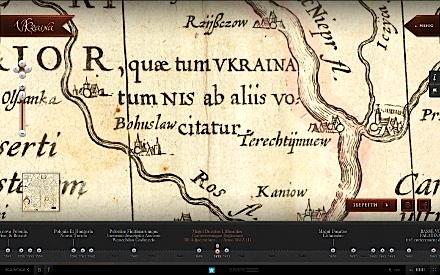
Interactive map which first mentioned Ukraine – follow this link
http://www.vkraina.com/ua/maps#1613_1
Today, when Ukraine is once again at the crossroads – which way is there to go? To the west or to the east? – Many are convinced that there really is no other way for further development in Ukraine except the European way. Because, sooner or later, Ukraine will still return to its European roots. And the European Passport it already has – moreover, that was issued 400 years ago!

